
When you plan a trip on the New River in southwest Virginia, you will be floating into the past. The New River is an ancient river system, the oldest on the North American continent and second only to the Nile River in Africa as the oldest river in the world. It begins as two streams in the Blue Ridge Mountains of North Carolina, before merging into the New River four miles from the Virginia line. And therein lies another quirk of this ancient river – it flows northward rather than southward like most of the other major rivers along the eastern seaboard. It meanders some 160 miles through the counties of Grayson, Carroll, Wythe, Pulaski, Montgomery and Giles in Virginia before it turns into Bluestone Lake in West Virginia and emerges later as the Kanawha River at the Gauley Bridge. The New River ends its metamorphosis when it empties into the great Mississippi River.
Throughout its journey in Virginia, the New River flows through spectacular, untamed mountain scenery complete with craggy rock cliffs and magnificent gorges. Thus, the New River provides plenty of excitement for whitewater enthusiasts, with several major Class II – III rapids. There is also an abundance of flatwater to please motorboaters and canoeists.
Fishing is not to be missed in on the New River. Simply stated, the New rivals the James and Rappahannock rivers as one of the best fishing rivers in Virginia. It supports outstanding populations of just about every major freshwater game fish in the state: Smallmouth Bass, Spotted Bass, Largemouth Bass, Rock Bass, Striped Bass, Hybrid Striped Bass, Muskellunge, Walleye, Black Crappie, Channel Catfish, Flathead Catfish, Yellow Perch, Redbreast Sunfish, and Bluegill. State records caught from the New River include Muskellunge (45 lbs. 8 oz.), caught June 1, 2007, Smallmouth Bass (8 lbs. 1 oz.), caught March 12, 2003, and Walleye (15 pounds, 15 ounces), caught December 15, 2000. Claytor Lake, a mainstem New River reservoir, yielded the state record Spotted Bass (4 pounds, 12 ounces), caught January 1, 2020, and the state record Hybrid Striped Bass (15 pounds, 13 ounces), caught March 16, 2016. The New River is likely to yield new state record fish in the future.
Fast water and big rock outcroppings are a feature of the New River, spelling perfect habitat for big Smallmouth Bass and Flathead Catfish. Pull your canoe up on an island and fish with jigs or spinner baits to hook some fine trophies.
But that doesn’t mean the New is all fast water. Several lazy, slow stretches abound, where you can soak in the spectacular scenery of rock cliffs, old Indian settlements and tobacco farms, and still have luck fishing for Rock Bass near grass beds. The slow waters near the dams along the river will may yield big Flathead and Channel Catfish as well as Walleye and Smallmouth Bass when fished with jigs and live bait.
Outdoor recreation activities abound along the river. New River Trail State Park parallels the river for over 50 miles from Pulaski to Fries or Galax. It is a beautiful tract of land that allows hikers, horseback riders and bicyclists to take in the beauty of the river as it sweeps through southwestern Virginia. Plus, a trip to the historical Shot Tower State Park near Jackson Ferry is a must. The nearly-4,400 acre Claytor Lake in Pulaski County was created out of the river in 1939 by a hydroelectric dam, and is now a well-used recreational spot. The 400+ acre Claytor State Park adjoins the lake, providing campgrounds, cottages, a marina, and hiking trails for visitors.
Outfitters can be found all along the New River, so a quick call to a local chamber of commerce will put you in touch with an experienced guide who will eliminate much of the worry about planning a float trip along this historic Virginia waterway.
Maps & Directions
Float Trips
Five dams impede the free-flowing New River in Virginia: Fields Dam, Fries Dam, Byllesby Dam, Buck Dam, and Claytor Dam. But many of these can be portaged, and often provide some good flatwater fishing. Portage around Fields Dam requires navigating a short but steep drop over large bedrock on the right side of the dam as you approach it. Portage around Byllesby and Buck Dams is available, but requires carrying up to 0.5 mile around each dam. The portage around Fries Dam requires a shuttle of 1 mile downstream to Riverside Park in the town of Fries. There is no portage path around Claytor Dam, so paddlers have to take out at Claytor Lake State Park to shuttle around it. Be warned that large volumes of water are frequently released from these dams to generate electricity, so be ready to move ashore if you notice a sudden rise in the river.
Plan on floating one hour per mile under normal conditions, especially if you plan to fish.
NOTE: Approximately half of the access points noted on the map are developed public areas. The remainder are traditionally used sites that can accommodate a canoe or light jonboat and are designated on the map and on the float trips by a letter. Please respect all property by refraining from littering, blocking gates or access roads, and from camping in prohibited areas.
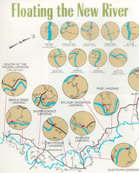
Mouth of Wilson to Bridle Creek
Map
Distance: 6 miles
Put in on the west bank of the river near the intersection of Routes 93 & 58. Cartop launch is always possible and launching a small jonboat is possible when flooding conditions don’t create large sandy areas at this access site. A one-mile backwater from Fields Dam, an old woolen mill, immediately greets the boater after launching. This slow water yields good catches of Smallmouth Bass, Redbreast Sunfish, and Spotted Bass. Portage the dam on the right side before continuing your journey to Bridle Creek. With the entry of Fox Creek just below the dam, an occasional trophy Brown or Rainbow Trout can be hooked. Easy riffles and scenic countryside can be experienced on this float. Take out on the left bank prior to the Route 601 crossing at Bridle Creek.
Bridle Creek to Independence
Map
Distance: 10 miles
This is the float for whitewater enthusiasts. Put in at Bridle Creek landing off Route 601 about 1.5 miles south of Bridle Creek community. The river spills over four sets of ledges to create some Class II and III rapids. For those who prefer to bypass such action, Penitentiary Shoals should be portaged on the left and Big Island Falls (near the north Carolina line) can be portaged from the right side. Fast water and big rock outcroppings always spell big Smallmouth b Bass and Flathead Catfish. Take the opportunity to pull your craft up on a cobble bar or an island and fish with jigs or spinnerbaits around the ample structure. Exit the river on the left side just beyond the Route 21 bridge or reduce your float by about 3 miles by taking out at the North Carolina Wildlife Resources Commission paddling access below the Farmers Fish Camp (State Route 1345) bridge in Allegheny County, NC on the right side of the river.
Independence to Baywood
Map
Distance: 12 miles
This is a trip for those in love with flat water and gorgeous scenery. Put in about three miles south of the town of Independence off Route 21. Be sure you get an early start or you will be doing more paddling than fishing. Short easy riffles and a few sharp ledges characterize all the fast water you will experience. Try casting into the numerous pockets for lively Spotted Bass action and near the grass beds for Rock Bass. Takeout is on the right side of the river just past the Route 58 bridge.
Baywood to Riverside
Map
Distance: 8.5 miles
Another quiet float for the most part, Baywood can be reached from either Galax or Independence via Route 58. Here, the New River winds around old Indian settlements and tobacco farms. Around two miles above the take out, you will encounter Joyce’s Rapids, challenging your boating skills and providing some outstanding Smallmouth Bass fishing opportunities. Be sure to fish the cool waters of Elk Creek where it joins the river directly above the take out. For those who opt for a longer float, there are camping facilities available in the vicinity of Riverside. Take out on the left near the intersection of Routes 274 and 94.
Riverside to Oldtown
Map
Distance: 6 miles
A wide channel, big islands, and grassy backwaters typify this stretch. Be sure to probe around the islands for Muskellunge, Smallmouth Bass, and Flathead Catfish. Your trip can be cut in half by taking out at a popular spot on the south side of the Route 94 bridge. Check out the local guide service for camping and boating opportunities. The Oldtown take out is on the right bank two miles past the Route 94 bridge.
Oldtown to Fries Dam (A)
Map
Distance: 2.5 miles
This is a short trip to take advantage of the power pool above Fries Dam, a 40-foot rock structure that once powered a thriving textile mill. The power pool harbors Largemouth Bass, Redbreast Sunfish, Bluegill, and an occasional Muskellunge. Be sure to look for signs of blue barrels strung across the river to warn boaters of the impending danger from the dam. Portage the dam on the left bank, following a very steep foot trail up to a public wayside off Route 94. Note that this portage requires a cartop carry to Riverside Park in the town of Fries about 1 mile downstream.
Fries to Byllesby Reservoir
Map
Distance: 7 miles
Launch at the DWR boat landing on river left off Rt. 94 at Riverside Park in the town of Fries. A broad river channel and loads of ledges and rock structure greet the boater. If you can pick your way up to Fries Dam one-half mile upstream, sharp rock ledges and deep currents produce trophy Smallmouth Bass, Walleye, and Channel Catfish all the way to the slow waters of Byllesby Dam just below the confluence of Chestnut Creek. These waters can be jigged or live bait fished for big Flathead and Channel Catfish, as well as Walleye and Smallmouth Bass. Take out about one mile above Byllesby Dam at a ramp at the end of Route 739 near Riverhill.
Fowler’s Ferry (B)
Map
Distance: 2.5 miles
This is a short piece of water sandwiched in between Buck and Byllesby dams. Put in off Route 635 on right side of river at an informal cartop launch. Beautiful bluffs, scattered islands, and rock ledges characterize this area. Nice stringers of Channel Catfish can be taken near the base of Byllesby Dam, while Smallmouth Bass, Spotted Bass, and Walleye also abound throughout the entire reach. Plan to paddle back to Fowler’s Ferry or prepare for a long portage around Buck Dam.
Fowler’s Ferry (B) to Austinville
Map
Distance: 7.5 miles
After working your way around Buck Dam, prepare for a scenic float through a bit of history. The area around Ivanhoe and Austinville were extensively mined for lead into the 1800s. Today, the landscape is dotted with farms, small towns, and towering cliffs. For the boater, easy water lies ahead along with terrific fishing. Walleye make their way all the way to the foot of Buck Dam and state record Walleye can be found in this stretch of river. The deep pools of this reach yield trophy Catfish and Muskellunge as well. Trout are caught occasionally near the mouth of Cripple Creek, a premier trout stream that enters the river here. Take out is a ramp near the Rout 636 bridge at Austinville.
Austinville to Jackson Ferry (C)
Map
Distance: 3.5 miles
This is a short but scenic float. Put in river right off Route 636 at a new, state-of-the-art boat ramp. New River Trail State Park hugs the river here. A deep, slow pool of water under the old steel bridge is sure to harbor lunker Muskellunge and Channel Catfish. Take out at New River Trail State Park, Foster Falls Village either above Foster Falls, a Class III–IV rapid, or below it. Be sure to visit the historical Shot Tower State Park before leaving the vicinity of Jackson Ferry.
Jackson Ferry (C) to Allisonia
Map
Distance: 13.5 miles
For those with a love of whitewater, you can put in above Foster Falls, a Class III–IV rapid, at one of the two new ramps constructed in New River Trail State Park, Foster Falls Village. For the more faint of heart, put in about 300 yards downstream below Foster Falls at the second ramp in the park. The Foster Falls area contains numerous rock gardens and sharp ledges – home to big Smallmouth Bass and Walleye. Downstream, beach your canoe on one of the many islands and fish the deep runs for Walleye and Catfish. Closer to Allisonia, the river begins to slow as you enter the deep waters of Claytor Lake. Take advantage of the cool water being supplied by Big Reed Island Creek, just above the landing. A nice, 10-car parking area and concrete ramp is available to Allisonia off Route 693 for those who prefer to do a little outboard motoring.
Claytor Lake
Map
21 miles in length
Claytor Lake is a 4,363-acre hydroelectric facility built in 1939 by Appalachian Power Company. Two major boat landings, one owned by DWR and one by Claytor Lake State Park are located close to Claytor Dam on the north side of the lake. Three other private ramps also give access to Claytor Lake. The 472-arce Claytor Lake State Park has four campgrounds, cottages, a marina, and hiking trails. Claytor Lake has an array of game fish species to satisfy the needs of any freshwater angler. Striped Bass, Hybrid Striped Bass, Walleye, Smallmouth Bass, Spotted Bass, Largemouth Bass, Black Crappie, Yellow Perch, Channel Catfish, and a variety of sunfish lurk below the rocky cliffs of the lake. Walleye run up the river as early as February, but their annual spawning runs peaks in March. Boats with outboard motors are recommended to navigate the water of the lake.
Claytor Dam to Peppers Ferry (D)
Map
Distance: 11 miles
Launch on the east bank off Route 605 after passing under I-81. Maneuver up to Claytor Dam to take advantage of some great Smallmouth Bass, Spotted Bass, and Flathead Catfish angling. Muskellunge are abundant from Claytor Dam to the West Virginia line. Be sure to fish the mouth of Little River as it enters New River directly below the dam. Water conditions from this landing to the West Virginia line when power is being generated at the dam. Be sure not to camp too close to the shore or get caught wading in mid-river when Claytor Lake Dam is releasing water. Consult Appalachian Power Company’s New River Flows and Forecast website for updated river conditions. This New River float is a relatively mild float with no major rapids and modest scenery. Exit the river on the left just above the Route 114 bridge at Peppers Ferry. Or, you can cut the trip in half by taking out or launching at the Bisset Park Boat Ramp (aka Dudley’s Landing) a short distance downstream from the Route 11 bridge on the right side of the river.
Peppers Ferry (D) to Whitethorne
Map
Distance: 8.5 miles
Informal put in on river left at the Route 114 bridge. The river slowly winds around tall cliffs, residential development, and the Radford Army Ammunition Plant. Scattered ledges and easy riffles characterize much of this float. Boaters beware of a Class II drop known as Arsenal Rapids. The rapid should be scouted and portage on the right bank. Excellent Smallmouth Bass and Muskellunge fishing can be found from the falls to Whitethorne, along with the usual river fish assemblage, including Largemouth Bass, and Flathead and Channel Catfish. Take out is at Whitethorne, a developed DWR boat landing off Route 623 on the right side of the river.
Whitethorne to Big Falls (E)
Map
Distance: 7 miles
Put in at the DWR ramp at the end of Route 623 at Whitethorne. This section is punctuated by several small ledges and riffles. Smallmouth action in this reach is nothing short of fabulous! It is not uncommon to hook several fish in the 2–4 lb class while using hellgrammites, jigs, or crayfish imitations. This is also one of the best areas on the lower New River to tangle with trophy Muskellunge. As soon as the river leaves Montgomery County and flows into Giles County (approximately 5 miles), it roars over a two-foot ledge known as Big Falls. Take out along Route 625 above or below the falls. This is a Class II–III run depending on water conditions. It is also a popular tubing spot for students from VA Tech and Radford University, so expect a lot of activity in the river during the warm months.
Big Falls (E) and Eggleston (F)
Map
Distance: 2.5 miles
This beautiful reach is typified by towering cliffs, deep pools, and a few challenging riffles. One difficult rock ledge is located on the right side of an island one mile above the Eggleston bridge. Anglers can expect to catch big Muskellunge in this section. Some of the largest catches of this fish have come from the area between Whitethorne and Eggleston. Be sure to cast large plugs or use adult chubs to increase your chances of landing a trophy Muskie. Smallmouth Bass fishing is outstanding as well. Take out on left bank just before the Eggleston bridge (Route 730) along Rt. 622 or continue downstream to a new Giles County access at the Eggleston bridge on the left side of the river.
Eggleston (F) to Pembroke (G)
Map
Distance: 6 miles
This is a short but beautiful float. Towering palisades line the water’s edge as the boater drifts slowly through the bends in the river. Short riffle areas are interspersed through this reach, inviting the angler to beach his craft and try flycasting a wooly bugger in the swirling pockets and runs. Take out off Route 623, on the right side above the bridge.
Pembroke (G) to Ripplemead (H)
Map
Distance: 2 miles
The outstanding scenery continues through this short piece of the river. Walker Creek, a notable tributary, enters the river about halfway through the trip. Several small islands dot the channel, offering a good opportunity to stretch and fish for Rock Bass and Smallmouth Bass in and around the channels. Fishing below the many small ledges can be productive as well. Take out off Route 636 on left bank, just under the Route 460 bridge.
Ripplemead (H) to Bluff City (I)
Map
Distance: 7.5 miles
Be on your toes for some whitewater action after entering the river at Ripplemead. A Class II rapid awaits approximately one mile from the put in, followed by several more ledges that produce great paddling fun. A long series of Class II riffles and ledges are located a mile below the confluence of Big Stony Creek. Clendenin Shoals, located near the town of Pearisburg, is the strongest rapid in the float and provides some excellent opportunities to land a big Smallmouth Bass or a monster Flathead Catfish. Bragging-size Muskellunge can also be caught in the deep holes. Take out on the left side of the river below the Route 460 bridge near Bluff City.
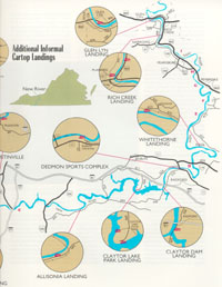
Bluff City (I) to Rich Creek
Map
Distance: 5.5 miles
Flat water dominates this run. Several small ledges and rock gardens can be handled easily, but beware of Narrows Falls, located below the town of Narrows. This is a Class III rapid that should be scouted thoroughly before attempting to run it. Narrows Falls drops around 7 feet in 50 feet of river. An old, crumbled dam at the end of the run forms several hydraulics that can be lethal to unsuspecting boaters. Fish the confluence of Wolf Creek at Narrows for Smallmouth Bass, Rock Bass, Muskellunge, and Catfish. Take out at the DWR landing on the right bank about 1 mile downstream from Narrows Falls. A launch site operated by the Town of Narrows at the mouth of Wolf Creek, just above the falls, can be used to avoid floating through Narrows Falls.
Rich Creek to Glen Lyn
Map
Distance: 5 miles
This is a gentle float, interrupted by a few short riffles and several large islands. The DWR Glen Lyn landing is located at a beautiful small park on the right-hand side, just above the Route 460 bridge. Take the kids on this short float and introduce them to the joys of float fishing. Catches of Smallmouth Bass, Redbreast Sunfish, Rock Bass, and Muskie can be expected in this reach of the river. Around seven miles of the river flow through Virginia before leaving the state at this point, with new Giles County access sites upstream and downstream from Shumate’s Falls. Boaters should avoid floating through Shumate’s Falls, an extremely hazardous downstream facing horseshoe shaped rapid that can trap boaters who drop over it. Paddling the slow waters of Bluestone Lake when it is at full pond is not desirable either, so many boaters consider Glen Lyn to be the final stop on the scenic New River in Virginia.
Fishing
Bass:
The New River offers a variety of fishing opportunities as well as some real trophy fishing potential. Largemouth Bass, Spotted Bass, and Smallmouth Bass (called black bass) are all found in the New River. Smallmouth Bass are, by far, the most abundant of these black bass in the river.
March, April, and May are the top months to catch trophy-Smallmouth Bass from the river, but a good number of trophy “smallies” are also caught in July, August, and September.
Techniques that produce these large Smallmouth Bass include fishing nightcrawlers, soft plastics, and top water lures in the summer months. Anglers should do well year-round with any bait that mimics crayfish, which are the smallmouth’s preferred prey. During summer months, buzz baits worked around downed trees or weedbeds (particularly water willows) often produce strikes from lunker smallmouths.
Muskellunge:
The Muskie is the largest game fish found in the New River. The current Virginia state record, a 45 lbs 8 oz trophy, was caught in the lower New River in June 2007, earning the New River its reputation as a destination water for trophy Muskie.
Catching a Muskie can be a real challenge. It can take many, many casts to hook into one of these “toothy critters” but the excitement of fighting one is well worth the effort. Good numbers of Muskie can be found near every boat landing and in the river reaches in-between. Large crankbaits, jerkbaits, and in-line bucktail spinners are all good baits for Muskie. Live bait fishing (including the use of trout) can be an extremely effective fishing method in the winter months.
Walleye:
Since completion of the study, efforts have been made to protect and enhance the native Walleye fishery through selective broodstock collection and fingerling production at hatcheries in Virginia. Since 2000, over 1 million native Walleye have been stocked from Fries Dam to Allisonia, creating a sustainable Walleye fishery.
Walleye fishing in the New River is best during the winter months and peaks from February through May during the Walleye spawning season. Two main spawning grounds for river Walleye were identified during the Virginia Tech research study, Fosters Falls (in Fosters Falls Village, part of the New River Trail State Park), and the area upstream from there at Buck Dam. There are two boat ramps in the Village, both of which are best suited to shallow running jon boats. Below Buck Dam is a newly constructed parking lot and bank fishing access site at the end of State Route 636 in the Austinville area. The current Virginia state record (15 pounds, 15 ounces) Walleye was caught from the upper New River near one of these two areas. Small jigs tipped with minnows, plastic grubs, and minnow type jerkbaits are all effective Walleye baits.
Catfish:
All sections of the river have populations of Flathead and Channel Catfish. Good areas to fish for Catfish downstream from Claytor Lake include the river just below Claytor Dam, below Pepper’s Ferry Bridge (Route 114), the Whitethorne and Belspring areas (all three locations are in Montgomery County), and Narrows, Pearisburg, and Eggleston in Giles County. Upstream from Claytor Lake, catfish are numerous from Foster’s Falls to Allisonia (Pulaski and Wythe Counties), near Foster’s Falls in Wythe County, and in the Baywood and Independence sections in Grayson County.
Panfish:
Panfish typically caught from the river include Redbreast Sunfish, Bluegill, and Rock Bass. Rock Bass are found in the highest numbers, but their sizes vary between areas of the river. Good locations for nice-sized Rock Bass include Radford and Whitethorne in Montgomery County, and Old Town, Baywood, and Mouth of Wilson in Grayson County. Many of the major tributaries of the New River provide an opportunity to catch numerous sunfish in solitude. Some of the streams to check out include Big Walker and Wolf Creeks in Giles County, the Little River in Floyd and Montgomery Counties, and Reed Creek in Wythe County. Since these streams are primarily on private lands, anglers should ask streamside landowners for permission to fish them.
Biologist Reports
Regulations
Bass
- New River-Fields Dam (Grayson County) downstream to the VA-WV state line and its tributaries Little River downstream from Little River Dam in Montgomery County, Big Walker Creek from the Norfolk Southern Railroad Bridge downstream to the New River, and Wolf Creek from the Narrows Dam downstream to the New River in Giles County (This does not include Claytor Lake which is delineated as: The upper end of the island at Allisonia downstream to the dam.):
- No bass 14 to 22 inches, only 1 per day longer than 22 inches, 5 per day in the aggregate.
Walleye
- New River upstream of Buck Dam in Carroll County:
- Statewide size and creel limits apply, with no Walleye less than 18 inches, creel limit 5 per day
- Claytor Lake and the New River upstream of Claytor Lake Dam to Buck Dam in Carroll County:
- Year round: No Walleye 19 to 28 inches; 2 Walleye per day
- New River downstream from Claytor Dam:
- Statewide size and creel limits apply, with no Walleye less than 18 inches, creel limit 5 per day.
Muskie
- New River-Fields Dam (Grayson County) downstream to Claytor Dam (includes Claytor Lake):
- 1 per day
- No Muskie less than 42 inches
- New River-Claytor Dam downstream to VA–WV state line:
- 1 per day
- June 1 to last day of February: No muskellunge 40 to 48 inches
- March 1 to May 31: No muskellunge less than 48 inches
Other Species
Note
North Carolina fishing licenses or permits are honored on the mainstream portion of the river from the confluence of the North and South Forks of the New River in North Carolina (Alleghany County), downstream to the confluence of the New and Little Rivers in Virginia (Grayson County).
News
Facilities, Amenities, and Nearby Attractions
The Department has numerous boat ramps along the river, including new facilities at Byllesby, Austinville, and Pembroke. A float guide, showing the location of public access to the New River is available under the Maps section.
The New River Trail State Park does have a variety of facilities and camping areas adjacent to the river.
News
More Information
Please contact the Marion Regional DWR Office.